Warm, cold and occluded fronts.
This is a quick summary of meteorology as it applies to gliding, designed to complement the talk which we gave on the 6th October. It is aimed at those with minimal experience of either gliding or met. The focus is primarily on the sort of flying that people will be doing during their training at Portmoak, although it does cover thermals to some degree as well.
It is not intended to be particularly comprehensive, merely a starting point. The more experienced/curious are directed towards the further reading section.
Gareth Francis, 6th October 2004.
One of the first lessons learned by new glider pilots is that Gliding, more than almost any other sport, is dominated by the weather. One of the most important skills a pilot develops is the ability to read the weather, on the small scale of knowing exactly where that thermal core is, on the medium scale of being able to estimate how the weather is likely to develop throughout the course of a flight and on the larger scale of deciding which days to fly on. There is probably nothing that makes as much difference to what you can achieve so much as simply picking the right days on which to fly!
Two of the questions we are most frequently asked by new and propective pilots are (more or less): "what is good gliding weather?" and "how can you predict when that will be?" These are the questions which I have attempted to (begin to) answer here.
Naturally this is merely a whistle-stop tour of an enormous and fascinating subject and I don't have nearly enough time and space to do it justice. However, it should cover everything you need to know to get the most out of your training, that is, to know which days are worth flying on and why. If you do want to know more and you have a spare outside course next year I highly recommend taking Met 1.
Before diving into the details of gliding and it's love/hate relationship with the weather, we'll take a quick look at the basics of the atmosphere and the types of weather that particularly affect us here in Scotland.
Before we begin to talk about the weather itself, a quick recap of what exactly this sea of air that we live at the bottom of, and of course will be exploring the lower depths of, is. (You don't really need to know this; it's here purely to satisfy my sense of completeness so if you're allergic to long words feel free to skip it.)
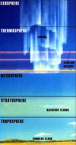
The air at sea level, and indeed over all the parts of the atmosphere we will be concerned with, is a mixture of about 78% nitrogen, 20% oxygen, 1% argon, traces of various other gases and, from our point of view critically, water vapour (we'll come back to this later). The atmosphere is generally considered to be divided into several major layers, characterised by the temperatures found there.
The lowest layer, in which virtually everything we call weather takes place is the troposphere. The temperature here decreases with height. The top of the troposphere is called the tropopause and its height varies from about 7km at the poles to around 17km at the equator.
The next layer is the stratosphere, so called because the temperature increases with height leading to stratification. (The temperature increase is caused by photochemical reactions involving ozone.) The top of the stratosphere is called the stratopause and is at a height of around 50km.
Above this the temperature decreases with hight throughout the mesosphere. The top of the mesosphere is called the mesopause (are you starting to see a pattern here?) and is at around 80km.
The thermosphere comes next and finally the exosphere. Here we have things like airglow, the aurora, and the odd, probably highly ionised, molecule but nothing you would describe as actual air.
The atmospheric pressure at the Earth's surface varies from about 900mb in the middle of an intense Hurricane to about 1050mb in the middle of Siberia in winter. The average surface pressure is about 1013mb and decreases with height at a rate of about 30mb per 1000ft. (Incidentally, this means that on a high wave flight you are above 50% of the atmosphere.)
Since the atmospheric pressure varies somewhat, air tends to flow from areas of high pressure to areas of low pressure—we get wind. However, because we live on the surface of a rotating sphere the air is also affected by a Coriolis force. This means that if it wasn't for friction the wind would actually blow parallel to the isobars (see below).
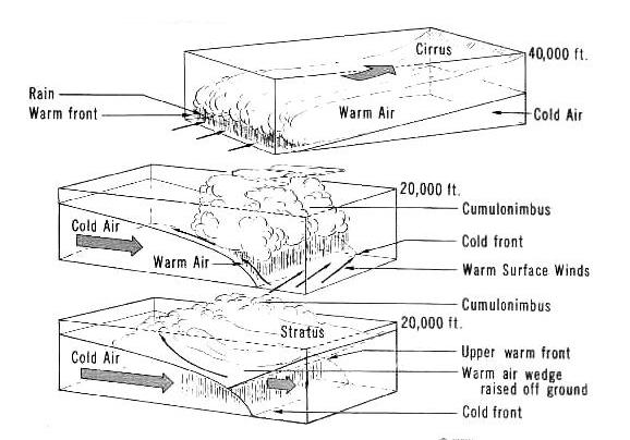
Obviously the air in different places, or in the same place at different times, can be very different in terms of temperature, humidity and the typical weather associated with it. We refer to large areas of similar air as air masses. The dividing lines between air masses tend to be quite sharp compared to the overall size and these dividing lines are known as fronts. We are particularly concerned with active fronts, that is one in which a cooler air mass is undercutting a warmer one (a cold front) or a warmer airmass overriding a cooler one (a warm front). Both generally lead to precipitation.
The release of latent heat due to condensation of water vapour in these fronts is enormous and provides the energy which drives mid-latitude depressions.
Warm, cold and occluded fronts.
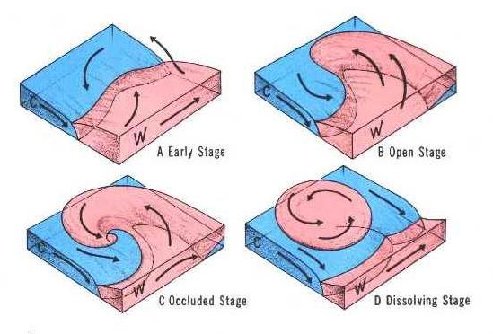
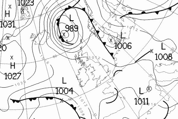
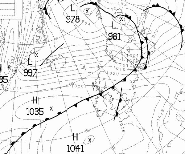
For most of the year the weather in the British Isles is dominated by depressions, otherwise known as cyclones or, somewhat vaguely, as low pressure areas. A mid-latitude depression begins its life as a wave or kink in the front dividing cool polar air from the warmer tropical air mass. As the wave grows the pressure at the centre of the depression drops and the system intensifies and begins to rotate. The depression migrates from west to east and forms a characteristic comma shaped mass of cloud. Starting at the centre the cold front starts to catch up with the warm front forming an occluded front.
Mid-latitude depressions are generally associated with rain (mostly on the fronts), high winds (near the centre of the depression) and general unpleasantness.
Development of a mid-latitude
depression
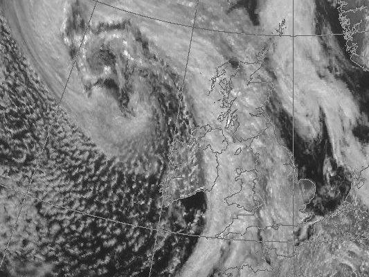
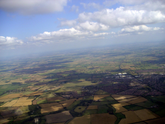
Visible satpic for 1st October 2004 12:00. A
depresion aproaching the British Isles. The cold front and
convection in the unstable air behind it is quite prominent.
One of the most useful methods of visualising what the weather is doing over a large area is the synoptic chart. This is a map showing surface pressure, areas of high and low pressure and weather fronts. Isobars join points of equal pressure and are typically spaced at 4mb intervals. Cold fronts are marked with triangles, warm fronts with semi-circles, both in the direction of movement.
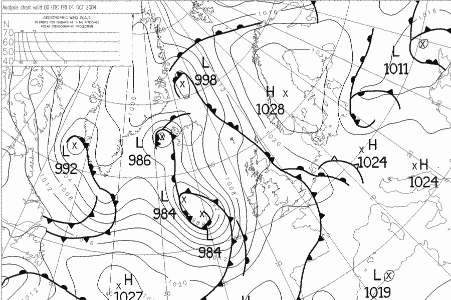
Synoptic for Midnight, Fri 1st October.
One of the reasons that the synoptic chart is so useful is that, for the mid-latitudes, it is a good approximation to say that the wind at height is parallel to the isobars (known as the geostrophic approximation). This means that at a glance we can determine the general direction of the wind. (At the surface the wind direction is generally about 30° less, i.e. anticlockwise, due to friction with the ground.)
The synoptic chart also tells us how strong the wind is. The closer the isobars are together the greater the pressure gradient force. Since the Coriolis force must also increase and neither the Earth's radius or the latitude are changing the wind speed must also increase. (Rather vague reasoning there, but it works and you're not really interested in the maths are you?) In the top left corner of the chart there's a scale to tell you what isobar spacing corresponds (in theory) to what wind strength at different latitudes.
OK, occasionally we do get some nice weather and the reason is usually an anticyclone. A large area of slowly descending air with high surface pressures. The weather is generally fine and sunny, hot in summer, cold in winter. So, is it any good for gliding? No, not really. Never mind, it's still better than being rained on.
The key point to remember is that, in the northern hemisphere, the wind goes anticlockwise around low pressure areas and clockwise around high pressure areas (in the southern hemisphere, the opposite). The other key point is that this is due to the Coriolis effect and not, as a former member said on his bronze exam, the coriander effect.
The principle behind hill lift is very simple: when the wind blows against a hill the air can't go through it so it has to either go over it or around it or, in reality, a bit of both. Obviously in the case of a long ridge it will mostly go over, in that of a sharp pinnacle mostly around. Therefore the former is rather more likely to produce useful lift than the latter.
The wind doesn't necessarily have to be blowing directly up the ridge in order to produce useful lift, although this is obviously the ideal. In general an angle of up to 45° is acceptable, depending somewhat upon the terrain.
Fortunately at Portmoak we are endowed with several such ridges. Bishop hill has ridges facing south, west-south-west, west, north-west and connects with the north facing Lomond Hills. Benarty faces north-west at the end closest to the airfield and north at the far end. On the opposite side of Benarty, facing east towards Ballingry there is Cemetery ridge and beyond it the far side of Benarty has been soared in suitable conditions.
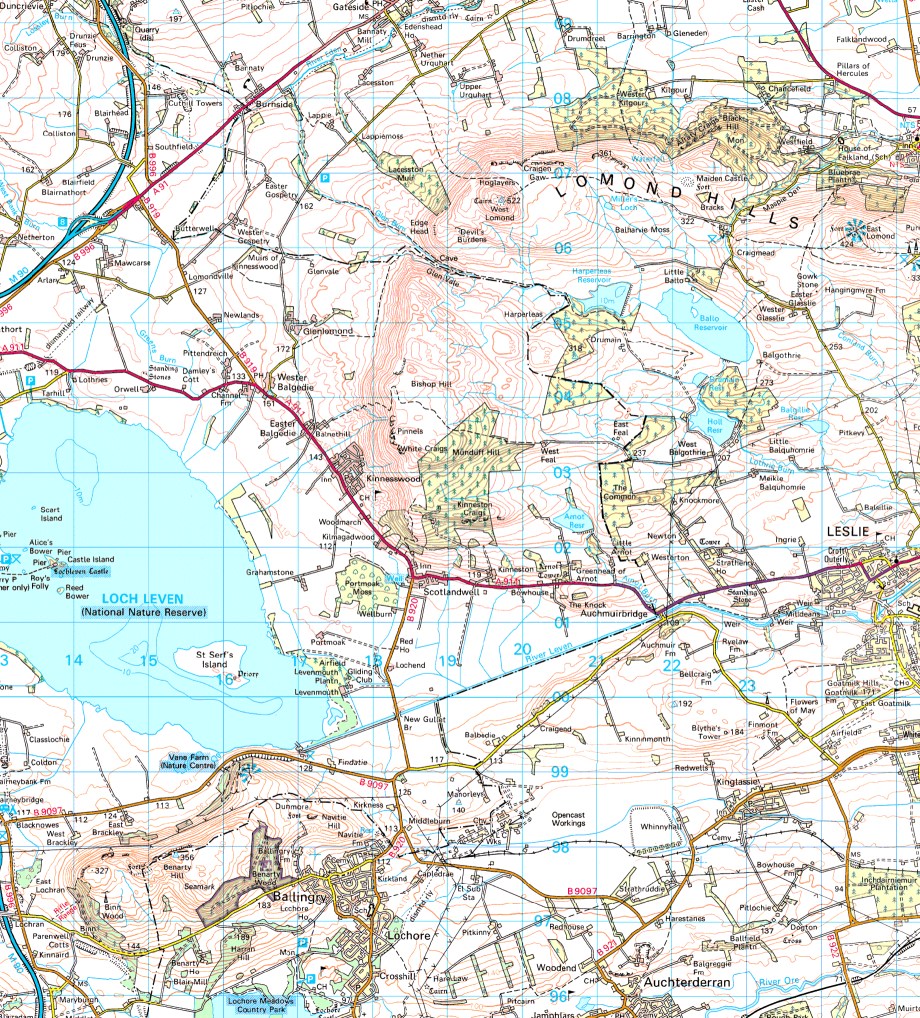
Map of the area around Portmoak.
All of these except the last two can be expected to work reasonably reliably given the appropriate wind direction. This means that all wind directions from south through west to north are catered for. As for the wind strength required the minimum for reliable lift is around 10kts but Bishop in particular might work with less, particularly on a warm afternoon with the sun on it.
24th April 2002—a nice ridge day,
with the odd thermal to liven things up. I did my five hours
that day.
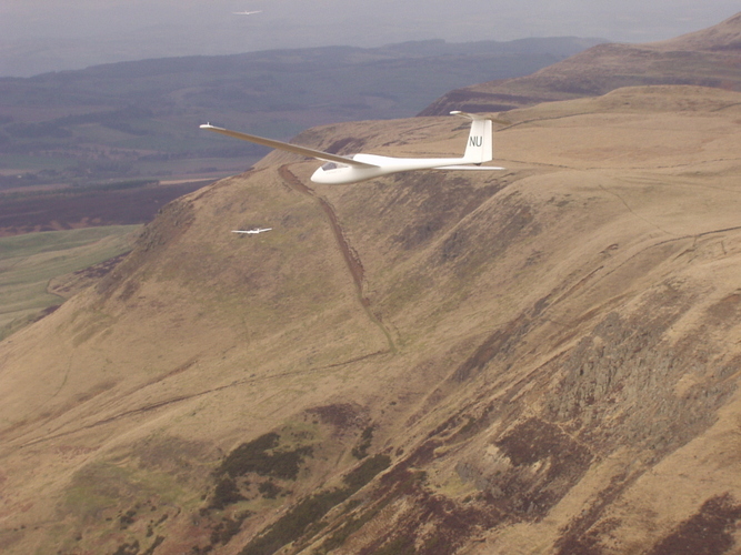
A glider in hill lift.
The theory is as follows: on a warm sunny day the sun heats the ground which heats a thin layer of air immediately above it. This rises in bubbles (or perhaps columns) known as thermals. The weather requirements are plenty of sun (so spring or summer), an air mass which is unstable enough to allow convection but not so unstable that it degenerates into showers, preferably not too windy and not easterly (because we get cold damp air off the sea). The ideal is a ridge of high pressure following a cold front in late spring or summer with a light westerly. Sadly the thermals around Portmoak tend to be a bit pathetic due to the proximity of large amounts of water. The only solution is to get away and head inland which is easier said than done.
Don't give up altogether though—every summer we go off to inter-uni task week somewhere in England where they do have real thermals.
12th May 2002—an excellent thermal
day.
Down south: thermals over Bicster.
When the wind blows over the mountains, under the right circumstances, a train of standing waves can be set up downwind. These waves can go to much greater heights than the hill causing them—the absolute altitude record for a glider is over 49,000ft and the British record (set in Scotland) is only about 10,000ft less. Equally importantly wave lift can be very strong (last Saturday, for example, I was getting climbs of over 10kts) which means that you can fly at impressive speeds, and therefore travel a long way (another example: last Thursday John Williams flew over 850km from Portmoak, although admittedly, unlike me, he is a good pilot flying a good glider).
So what conditions do we need to produce wave? Well, the good news is that while wave can happen at any time of year it's actually more likely in the autumn and spring. Most fundamentally, we need some obstruction upwind so we really need a north westerly wind, although weaker, less extensive wave can occur in a southerly. Next, the wind needs to be the right strength, at least 15kts on the ground. Although there is no definite cut-off, much above 20kts is getting too strong. Also the temperature profile needs to be right. Unfortunately, this is much harder to predict. You can try asking more experienced pilots what they think and why, but quite frankly they're as likely as not to get it wrong. Lastly, we would like some moisture so that clouds form and mark the lift for us, although the wave can still occur with it, but not so much that the gaps fill in because that gets a bit frustrating if you're below it and scary if you're above it.
So, to summarise, you need a roughly north-westerly wind of 15–20kts, a bit of luck and a lot of persistence! There's an account of what the weather did on two particular wave days here
21st Feb 2001—a clssic wave
day.
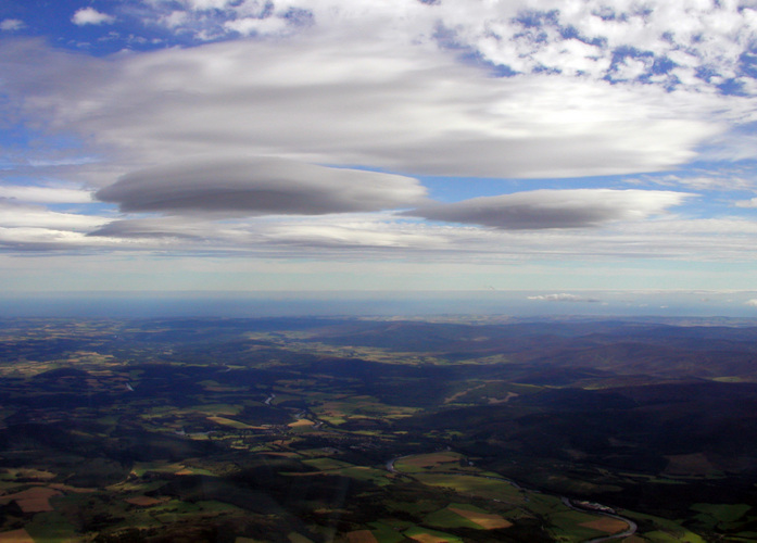
Wave clouds over Aboyne.
Murphy's law: anything that can go wrong, will go wrong.
Probably the most common cause of completely unflyable weather is one you will be quite familiar with: rain. Situated in the north east corner of the Atlantic, Scotland is amongst the world's most desirable destinations for mid-latitude depressions. Throughout the autumn, winter, spring and, not infrequently, summer they arrive every few days, each one bringing with it it's attendant flock of fronts, secondary depressions and high winds.
The only good news is that modern forecasting models are pretty good at predicting what depressions are going to do several days in advance; although let's face it, they certainly get enough practice. It is therefore relatively easy to look at a forecast synoptic on Wednesday and say whether or not there's going to be a depression on top of you on Saturday.
So we have two nice simple situations: no depression around—no problems, at least from that particular source; depression on top of you—don't bother getting out of bed. The problem is that when we start looking at real charts we find that most of the time, especially in the autumn and spring, there are several depressions around, or likely to be so, but none actually over Scotland. In this case the factors that we are interested in are the wind strength and direction, and precipitation.
Forecast wind strength and direction we can get directly from the synoptic chart. Close to the ground the effect of friction with the surface means that the actual wind is typically rotated by about 30° anticlockwise with respect to the geostrophic wind. Similarly the geostrophic wind scale gives a good approximation of the wind strength.
Precipitation is harder because most rainfall is associated with fronts and forecasting the speed at which fronts will move with any accuracy is hard. Often an otherwise nice day is ruined by a front which either didn't clear by the time it was expected to, or arrived earlier than expected.
Many a nice flying day has been brought to an early and damp end by the arrival of a rain shower. Showers occur in unstable, convective airmasses, and are possible whenever the cloud tops are above the freezing level. If sufficiently large and vigorous, such cumulonimbus clouds can produce thunder and heavy rain or hail.
Obviously it is impossible to make predictions for individual showers; however, most of the time it is fairly easy to forecast showery weather. Broadly speaking, this is likely to occur when there is deep instability in the atmosphere and the airmass is being heated from below. One situation in which this frequently occurs is the typical British summer day which starts off fine, thermic, cloudbase of 3 or 4 thousand feet with cumulus maybe a couple of thousand feet deep until around mid-afternoon the first cumulus tops penetrate the thin stable layer and find nothing to stop them. The next thing you know, the cloud tops are at 20,000ft and you're dodging rain showers.
Another situation which is perhaps more relevant to flying from Portmoak is one which occurs quite frequently during the winter. A depression over Scandinavia combined with an area of high pressure in the North Atlantic results in very cold air being dragged down from the arctic. The air coming off the ice sheet might be at a temperature of –30°C. As it travels over the relatively warm North Atlantic it is being heated strongly from below and some impressively big snow showers can develop by the time all this hits Scotland. This leads to cold weather and heavy snow showers, particularly on the coast; once the air is over the (cold) land the heating is removed and the showers die out. A less dramatic version of this often leads to showery weather behind cold fronts in general during the winter.
The possibility of showers doesn't altogether rule out flying. You can still try and fit flights in between the showers or, sometimes, fly around them. However, it does make for stressful ground handling and it is vital that aircraft are properly parked if showery weather is expected.
If you get cut off from the airfield by a
shower...
you're likely to end up in a field.
On a nice thermic day with light winds, the net effect is often to draw air inland off the sea. This is known as the sea breeze and the boundary between the original air mass and the encroaching sea air as the sea breeze front. The sea breeze front often produces enhanced thermals and excellent soaring. However, the sea air behind the front is cold, damp and, from a glider pilot's point of view, useless. At sites like Portmoak that are near the coast sea breezes can be a menace.
Any day which is thermic inland is almost guaranteed to produce a sea breeze unless there is a sufficiently strong westerly wind to keep it at bay. The day will typically start off with weak thermals, getting steadily stronger as the day progresses until around lunch time everything is suddenly cut off, the wind becomes easterly and all hopes of soaring are abandoned. The only solution is to get away before the sea breeze arrives and get inland.
Low cloud can sometimes be a problem. If the cloudbase is generally low there's not much you can do about it but if the hill has disappeared in orographic you may be able to soar in front of it.
A particularly frustrating preventer of flying is fog. Most likely to occur in easterlies but it can happen in light winds from other directions. Fog can be very localised in nature so the only way to be certain of what's going on is to be there (or phone someone who is).
Too many days of fog can make you want to
do this.
Flooding is less of a problem than it used to be as the drainage on the airfield has been somewhat improved. Nevertheless it is still a real possibility in winter and it doesn't matter how good the weather overhead is if the airfield is under water. On the other hand it does make a good excuse to visit Millfield.
Easterly winds almost always lead to poor flying weather. The sea air prevents any possibility of thermals and the only ridge which might work is Cemetery Ridge (AKA Dead Man's Ridge) which if you're lucky, and the wind is the right direction (just south of east) and sufficiently strong, will give you just enough height to get back without embarrassing yourself.
A light easterly wind is also likely to bring fog. In winter easterlies tend to be cold and damp. Generally best avoided altogether unless you're desperate to practice circuits or launch failures.
I should emphasise that this is roughly what I do. It isn't the only way.
First look at the forecast synoptics. Don't bother with anything more than 96 hours in the future—it might as well be complete fiction as far as we're concerned. Do the wind strength and direction look OK? If not how big a change would be needed to make them OK? If so how big a change would be needed to mess them up?
Next, are there any fronts or similar nasties likely to be over us? Predicting the timing of fronts with any accuracy is hard so don't give up straight away if there's one right over Scotland at 12:00 on the day you want but no others around—if they've got it a bit wrong it might not be there until the evening, or it might have gone through the previous night.
Check the met office 3 day forecast for Southern Scotland to see what they think. If it's a possible wave day and the right time of year you could see what Jack Harrison thinks, but don't rely on him.
Keep checking back every 24 hours. The forecast can and does change from one day to the next, sometimes dramatically.
Most importantly, believe your senses: if you go outside on Saturday morning and you're getting wet then it's raining, whatever the weather forecast said it was supposed to do on Friday night! More seriously, if you go to the top of the JCMB you can see exactly what the weather is doing over Portmoak.
I'm sure there's plenty more...